Tuesday, March 29, 2016
Ezigrade 2.7.0.38
Have added in a routine for data thinning. This allows you to cut down the number of points in the job. Handy for speeding up the program when doing triangle based grading without compromising accuracy too much.
Thursday, March 24, 2016
CDS 2.7.0.34
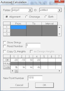
When running Autoroad we now have an option to automatically set the codes of any new points that are created.
Wednesday, March 23, 2016
Ezigrade 2.7.0.37
If you have a multi-section Ezigrade job and one of the sections is 4way, then it can forget to grade some of the sections.
Friday, March 18, 2016
Ezigrade 2.7.0.36
We have created two new measurement routines:
- You can draw a line and show the distance, grade and design grade
- You can draw an enclosed polygon and the area is reported. Finish with the "enter" key and the respective volumes if available are shown.
- + toggle point display
- P toggle point number
- H toggle height display
- D toggle design height display
- "parallel lines" toggle contour display
- "desktop" zoom extents
- "desktop with magnifying glass" zoom window
- "line with text" measure length, grade and design grade
- "polygon" measure area. Enter at end displays volumes
Friday, March 11, 2016
Ezigrade 2.7.0.35
Ezigrade - The GPS options have been tested in a John Deere environment. To pick up data:
- open a new job
- from file menu - GPS - set serial port
- File - GPS - Pickup
- File - GPS - OPtions and set pickup parameters
- Drive around your paddock
Ezigrade 2.7.0.35
Ezigrade now allows you to set common links beween sections as a hinge line. The two sections then hinge together. This only works when both sections are designed as planes.
Thursday, March 3, 2016
CDS 2.7.0.33
When displaying by layer - points with null heights could have a height displayed onscreen.
There was an issue when rounding bearings to the closest 5 seconds.
There was an issue when rounding bearings to the closest 5 seconds.

