Thursday, July 27, 2017

ezigrade 2.8.0.29

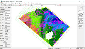
Have added in a new waterflow option. Click on the waterflow icon or the "View" -> "Calculate Drainage Lines". It asks for the number of seed points. These are random start points of how the water will flow along the surface. The flow is a low speed simulation under low waterflow conditions.


Wednesday, July 12, 2017

ezigrade 2.8.0.29

Ezigrade now has a bump map option. A bump map is where a cartographer shades one side of a ridge in a dark hue while shading the other side in a lighter hue. This gives the illusion of 3D and helps to visualize the surface. In the surface colors dialog you will see the extra "bump map" checkbox and a scaling value. Simply tick the box.


We have found a bug with "ponding" display and this now also supports a bump map.

The south west quarter has been graded - hence the lack of ponding.