Added in an option to export a Trimble Multiplane txt file. Get your UTM / State Plane data into multiplane.
We can also export the file using design heights. This is a hack to allow us to get Ezigrade or Civil data into agform3d which supports a multiplane import. And hence allows us to get data to Topcon tractor for grading.
Tuesday, December 12, 2017
Wednesday, November 29, 2017
Ezigrade 3.05
Have expanded drain routines to optionally include extra banks around edge of drain. This allows us to create contour banks, head ditch's etc.
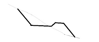 For example the above screen shot shows how this can be used to create a contour bank.

Tuesday, November 7, 2017
Thursday, September 14, 2017
Ezigrade 2.8.0.45
Ezigrade now has the ability to match edges of "variable grade" sections. You need to make sure that

- All common edges are defined as hinge lines. (Left click on the section edge and then under File menu you will see the option to toggle on the hinge option)
- Use the option to add in extra points along section lines. Ezigrade needs points along the line that are in both sections to match edges.
- At present all sections need to be variable grade that are joined together. (or all planar) This will be relaxed in a future release
Please remember that the drain(/bank) routines also allow you to achieve similar outcomes.

Thursday, July 27, 2017
ezigrade 2.8.0.29
Have added in a new waterflow option. Click on the waterflow icon or the "View" -> "Calculate Drainage Lines". It asks for the number of seed points. These are random start points of how the water will flow along the surface. The flow is a low speed simulation under low waterflow conditions.


Wednesday, July 12, 2017
ezigrade 2.8.0.29
Ezigrade now has a bump map option. A bump map is where a cartographer shades one side of a ridge in a dark hue while shading the other side in a lighter hue. This gives the illusion of 3D and helps to visualize the surface. In the surface colors dialog you will see the extra "bump map" checkbox and a scaling value. Simply tick the box.
 We have found a bug with "ponding" display and this now also supports a bump map.
 The south west quarter has been graded - hence the lack of ponding.


Wednesday, June 28, 2017
Ezigrade 2.8.0.28
Couple of bug fix's.
(1) Some grading parameters not being set unless we run the grading routine. This can cause the software to crash.
(2) Volumes of drains.
(1) Some grading parameters not being set unless we run the grading routine. This can cause the software to crash.
(2) Volumes of drains.
Wednesday, June 14, 2017
CDS 2.8.5
Fixed bug when displaying angles for closed strings. The start/end angle was being written twicw
Thursday, May 11, 2017
Ezigrade 2.8.0.23
Have added in an icon that displays arrows that shows water flow direction.

Ezigrade will now use constraint points while doing a hinged plane design; which can give you greater control of the finished surface.
When picking up points using GPS we can click on an icon to enter a single point, plus an icon to enter in a code on a GPS point.
Thursday, March 23, 2017
Ezigrade 2.8.0.15
When staking out to a line using GPS in Ezigrade we now show chainage and offset along the line for operator feedback.


A few GPS parameters are now stored to the registry. This means if you are picking up data with Ezigrade it means you can close and reopen the program and not have to re-enter any setup parameters.
Wednesday, March 15, 2017
CDS 2.8.4
Have removed some screen flicker when redrawing screens when doing pans and zooms etc.
There was a bug in Cogo -> Chainage and Offset -> Point and Bearing. The start point number was changing midway through calculations leading to an error.
There was a bug in Cogo -> Chainage and Offset -> Point and Bearing. The start point number was changing midway through calculations leading to an error.
Monday, March 13, 2017
Ezigrade 2.8.0.9
We have simplified the entry of field sections. For example if you:
- Enter in a some section edges that are closed Ezigrade now prompts and will enter in the new section automatically
- You can enter in a series of edges inside an existing section. You will be prompted and Ezigrade will split the field into 2, creating two new sections and deleting the original
- You can enter in a series of edges to the edge of a single or number of existing sections. Ezigrade will prompt and enter in the new section.
- When deleting sections - you are prompted on whether you want section edges deleted. If they are part of another section then they are not deleted.
Ezigrade 2.8.0.0
Ezigrade now contains routines to incorporate surface drains into your design. They are agriculture specific and have been made as simple and as easy to design as practicable. When-ever possible the deign process is visually based. A drain can contain as many drains as necessary.
Three applications that come to mind are:
Three applications that come to mind are:
- For heavily ponded situations (American Mid West); we can design surface drains that drain ponded area's before running grading routine that runs water to the edge of the job
- A design for a bank or drain directly onto the picked up or previously designed surface
- Adding a drain to match or included in the design (as-built surface)
Tuesday, February 14, 2017
CDS 2.8.1
When doing a print preview / print with the sheet rotated. Then some string fills were not being displayed. Fixed.

CDS2.8.1
Changes to short line / short arc table. If we are displaying short lines then a docked list box is shown to the right of the current view. This replaces the two pop up list box's as used previously.
When creating a DWG short lines were wrong when only displaying bearings.

When creating a DWG short lines were wrong when only displaying bearings.

Subscribe to:
Posts (Atom)