Return

Use Back buuton on your browser to return. Otherwise click here for Foresoft Home.

Wednesday, November 16, 2016

Ezigrade 2.7.0.58

PDF Report:
Have added some extra functionality to the PDF report.


  • You can add in user defined text at the start. It can contain anything that you want. 
  • Have given user the option of displaying screen capture for natural/design/difference as either 1 or 2 screen grabs per page.
We have also added in an "AGD" export. Useful for getting your job into TerraCutta.

Thursday, November 3, 2016

CDS 2.7.0.41

Have made the following improvements / bug fix's.


  1. Ability to pick up the current surface as a design along a profile. You would use the following. First get a string and interpolate a profile and sections along it. In Profile View right click and select the option "Design From Surface". Make sure you have the appropriate surface displayed. The design will be created on the active design.
  2. Fixed issue when importing KML files. Coordinates which included heights were picking up the lat and lon in the wrong order.
  3. if selecting things by polygon you needed to hit enter then escape to cancel. Now only need to hit escape.
  4. Unicode LandXML files will now import.

Wednesday, November 2, 2016

Ezigrade 2.7.0.57

Added in Constrained Points.

We have added in the ability to add in a point or a series of points that we call a "constrained point". This forces our design to warp the surface so the height on our graded surface match's the fixed height of this point. There are numerous uses's for this function. For example we can add some points along the edge of the job that match the edge of a designed drain. Our field will now match.

In the example below the design on the left is what we have with no constrained point. We have shown it's position as a reference. The design on the right is with a constrained point. You will notice that the contours are warped around the right edge to match the constrained point.

Tuesday, November 1, 2016

Ezigrade 2.7.0.56


  • When autocreating surfaces and contours. Program now uses contour intervals appropriate to the data range of the points in the job
  • When File - Open - types of files Farmscan  *.path ; import was not working - now fixed.
  • Broke Licence dialog on last update 

Tuesday, October 11, 2016

Ezigrade 2.7.0.55

A number of routines have been added/modified to improve the workflow and to "Dummy" proof the software. Enhancements include:


  • Section axes. You can now left click to select. The Axes is drawn at a larger scale and a grip box is attached. If you left click within the grip box you can rotate the axis visually. You can still enter a value manually if required.
  • You can now left click with a section and the appropriate section is displayed along the left edge.
  • Menu layout has been changed to streamline the workflow. All reports are now under the Report menu.
  • Previously when creating a plane solution, you needed to set both min and max values in either/or X and Y directions. Now only need to set the minX/minY. Unneeded parameters are now greyed out.
  • Get section grades was not working correctly if axes rotated.
  • When creating hinged sections - hinge was not correct if Axis of both sections was not the same.
  • When doing "grading by grid" software now checks if the number of rows and columns is too large - which means large solution times and prompts user for a larger grid.
  • When creating Contours - the Escape key will stop the process if needed.
  • When removing section links etc, everything is cleaned up.

Ezigrade 2.7.0.55

You can open up external data files directly:

From File - Open command then in the "Files of Type" drop down combo, you can search directly for a supported file.  If for example you have a AMW file called   job1.nez then you can open this file directly.

Ezigrade prompts you on any thing need to import it and a file called  job1.cdsdat is automatically created.


You can still use the File -Open and then the File - Import routines as previously. 

Sunday, September 25, 2016

New Phone Number

Our new number is  0456415865

Friday, September 16, 2016

CDS 2.7.0.40

Updates to improve CDS when you have multiple designs associated with a profile. There is a new function to set the design from the design heights on the points making up the reference line. There were a couple of bugs when plotting multiple designs.

Thursday, September 15, 2016

Ezigrade 2.7.0.54

Have simplified the adding of extra points along section edges. This gives "crisper contours" around the edges of fields and where fields join other fields.

Thursday, August 25, 2016

CDS 2.7.0.39

Some general functions to help export data to machine controllers. They are:

  • added in an option to data thin along strings. Particularly useful for data from 12D which can be quite dense. When sending data to for example a Kommando system - the files were too big for it.
  • added in breaklines to a LandXML file. 

Wednesday, August 10, 2016

Ezigrade 2.7.0.53

Have added in the ability to grade around a pivot. You do this when you have furrows running in concentric rings. You can have as many sections as you wish. If you don't have furrows then you use the traditional grading design method.


We have also fixed an issue with displaying surfaces in the pdf combined report.

Tuesday, June 7, 2016

Ezigrade 2.7.0.44

Added in a combined pdf report. It includes:

  • summary of volumes per section
  • summary of grades per section
  • optional screen shot of natural surface
  • optional screen shot of design surface
  • optional screen shot of cut/fill (difference) surface

Friday, June 3, 2016

CDS 2.7.0.38

File save and automatic backup has been made more rigorous. When running CDS will do an automatic backup at user defined intervals. A file job.cdsdatback is stored on your hard disk.
When closing down the job you are prompted to save the file. If you do then firstly a file job.cdsdatsave is created. The existing job.cdsdat is renamed to job.cdsdattemp. The file job.cdsdatsave is then renamed to job.cdsdat

Friday, May 27, 2016

CDS 2.7.0.36

Have strengthened the saving of data from CDS. The automatic update updates the data as it does now. It also creates another copy of the job data with an extension of .cdsdatbak  In the event of data loss you can rename this backup file to an extension of .cdsdat and use this.

Thursday, May 19, 2016

Ezigrade 2.7.0.42

When importing Trimble Field Level 2 files (.gps)  conversion was defaulting to meters even though job was set up in international or survey feet. Fixed.

Friday, May 13, 2016

CDS 2.7.0.35

When selecting points by polygon only points displayed (either actual point, point number, heights etc) can be selected. Points not displayed are ignored.

Friday, May 6, 2016

Ezigrade 2.7.0.41

Ezigrade now supports State Plane coordinate systems when exporting data to google earth.

Tuesday, March 29, 2016

Ezigrade 2.7.0.38

Have added in a routine for data thinning. This allows you to cut down the number of points in the job. Handy for speeding up the program when doing triangle based grading without compromising accuracy too much.

Thursday, March 24, 2016

CDS 2.7.0.34


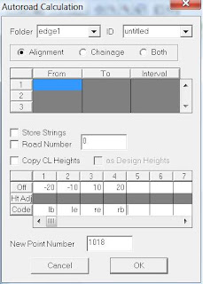
When running Autoroad we now have an option to automatically set the codes of any new points that are created.


Wednesday, March 23, 2016

Ezigrade 2.7.0.37

If you have a multi-section Ezigrade job and one of the sections is 4way, then it can forget to grade some of the sections.

Friday, March 18, 2016

Ezigrade 2.7.0.36

We have created two new measurement routines:


  1. You can draw a line and show the distance, grade and design grade
  2. You can draw an enclosed polygon and the area is reported. Finish with the "enter" key and the respective volumes if available are shown.
We have filled in the control bar with some new quick select icons


  • +  toggle point display
  • P toggle point number
  • H toggle height display
  • D toggle design height display
  • "parallel lines" toggle contour display
  • "desktop" zoom extents
  • "desktop with magnifying glass" zoom window
  • "line with text" measure length, grade and design grade
  • "polygon" measure area. Enter at end displays volumes 

Friday, March 11, 2016

Ezigrade 2.7.0.35

Ezigrade - The GPS options have been tested in a John Deere environment. To pick up data:

  • open a new job
  • from file menu - GPS - set serial port
  • File - GPS - Pickup
  • File - GPS - OPtions and set pickup parameters
  • Drive around your paddock
We have been working on simplifying the software and hiding details for casual users. When now do a grading, design and cut/fill surfaces are automatically updated. There is now a combo box to easily display different surfaces (ie natural / design / cut and fill)

Ezigrade 2.7.0.35

Ezigrade now allows you to set common links beween sections as a hinge line. The two sections then hinge together. This only works when both sections are designed as planes.


Thursday, March 3, 2016

CDS 2.7.0.33

When displaying by layer - points with null heights could have a height displayed onscreen.

There was an issue when rounding bearings to the closest 5 seconds.

Thursday, February 25, 2016

Ezigrade 2.7.0.26

Ezigrade doesn't give nag screen if the wrong triangles/contours are being displayed when doing certain processes. It now changes to appropriate surface automatically.

Thursday, February 4, 2016

CDS 2.7.0.32

Preliminary version to import a KML file from Google Earth.

Friday, January 29, 2016

CDS 2.7.0.25

When creating KML file for export to Google Earth. The contour colours are coming across correctly. They were hard coded before.

Thursday, January 28, 2016

Ezigrade 2.7.0.25

In Ezigrade have added in the ability to display gridded cut and fill values to google earth.


This gives a good visual check when driving around your paddock with your IOS or Android tablet to check heights.

Tuesday, January 19, 2016

CDS 2.7.0.24

Have added in an import option for LPI Lidar data which is in a grid format. This format is ascii and typical data starts like:

ncols   200
nrows 200
xllcorner 1234567.888
yllcorner 3323232.443
cellsize 10.0
nodata_value -9999.0
23.4 34.5 23.6 etc

Friday, January 8, 2016

CDS 2.7.0.23

There is a new bug when importing data files. Data was successfully imported but error occurred when trying to shut down import program. This is now fixed.